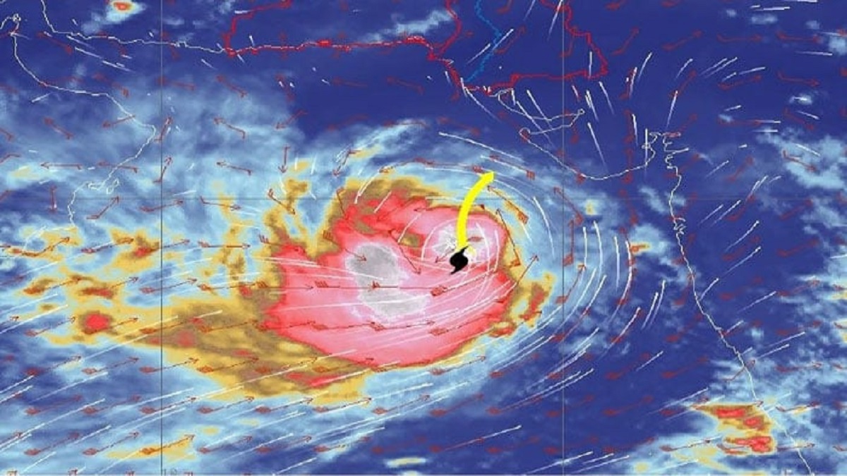
In a recent statement, the Pakistan Meteorological Department (PMD) expressed its concerns about the Very Severe Cyclonic Storm (VSCS) Biparjoy, which is forecasted to change its trajectory and move further away from Karachi.
According to the PMD, due to the current upper-level steering winds, VSCS Biparjoy is expected to veer north-northeastward and is most likely to cross between Keti Bandar, located in Southeast Sindh, and the coast of Indian Gujarat by the evening of June 15. The storm is forecasted to remain a VSCS, packing winds at speeds between 100-120 Km/hour and gusting up to 140 km/hour.
The PMD’s cyclone warning center in Karachi is keeping a close eye on the weather system and will provide regular updates as the situation develops.
In a comparison between the morning alert and the more recent one, there is a noted increase in the recorded distance of the cyclone from Karachi, Thatta, and Keti Bandar.
The PMD reports that the cyclone currently has maximum sustained surface winds blowing at speeds between 150-160 Km/hour with gusts reaching up to 180 Km/hour around the system centre. Furthermore, sea conditions in the vicinity of the storm centre are reported as phenomenal, with wave heights reaching up to 30 feet.
The PMD indicated that current environmental conditions, including a sea surface temperature of 29-30°C, low vertical wind shear, and upper-level divergence, are supportive of maintaining the storm’s intensity throughout the forecast period.
Earlier in the day, reports of light rain were received from some areas in Karachi due to rain bands and strong winds associated with the approaching cyclone. Rainfall was also reported in Gharo, Keti Bandar, and surrounding areas in the Thatta district.
Based on the latest forecasts, the Category 3 VSCS is expected to make landfall on the evening of June 15, between Karachi and Mandvi in India’s Gujarat. The cyclone is projected to maintain a northward trajectory until the morning of June 14, after which it is expected to re-curve eastward towards Keti Bandar in the Thatta district and the Indian Gujarat coastline.
Read More: Cyclone Biparjoy Prompts Emergency Measures and Evacuations in Pakistan’s Coastal Areas
Weather experts have listed several areas that are likely to be impacted, including Thatta, Badin, Sajawal, Tharparkar, Karachi, Mirpurkhas, Umerkot, Hyderabad, Ormara, Tando Allahyar, and Tando Mohammad Khan.
During a press briefing, Pakistan’s Climate Change Minister, Sherry Rehman, emphasized that Pakistan’s coastline, particularly an area known as Keti Bandar, is in the direct path of the cyclone’s landfall.
She informed that the government is currently overseeing evacuations in coastal areas, having already relocated about 62,000 people to 75 evacuation camps over the past two days. The minister also mentioned the possibility of voluntary evacuations in Karachi, which is not directly in the path of the storm but will certainly be affected by high-velocity winds and heavy rainfall.
According to reports from the Sindh government, a total of 64,107 individuals from the districts of Thatta, Sajawal, and Badin have been safely relocated so far.
The Minister expressed gratitude towards international satellite centers for their assistance and noted the concerted efforts being led by the Sindh and Balochistan governments, supported by the federal government, military, and Rangers.